Dr. Martin Béland writes about his research using LiDAR to measure the structure of tall trees at Whitaker's Forest (one of the Center's four research forests). Béland was a postdoctoral scholar at UC Berkeley's biometeorology lab from 2012-2014. He is currently an assistant professor at Laval University in Canada.
Whitaker's Forest sits on the southern slope of a ridge followed by the Generals Hwy on the west side of Sequoia National Park. The forest is located far enough down a winding forest road that it feels isolated, but not in an oppressive way; the majestic sequoia trees and singing birds around are of good company to visiting researchers, making it a very special place to work in.
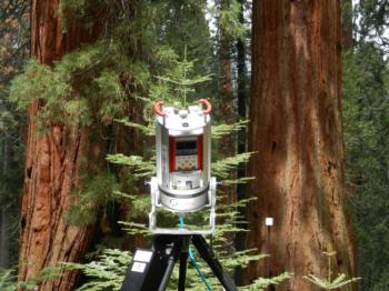
I visited Whitaker's Forest in May of 2014 to measure the structure of tall trees using a LiDAR instrument. LiDAR technology has great potential for measuring tree structure from a distance with an unprecedented level of detail. The time required to make and process the measurements is very short compared to manual methods, which allows sampling more trees, with more detail, more often. LiDAR sensors emit a series of laser pulses and measure the reflected energy to determine the position of objects in 3D space. They can be mounted on airplanes, on drones, or setup on survey tripods closer to the ground.
Whitaker's Forest is the furthest south of the Center for Forestry's four research forests.
When one wishes to describe the structure of such complex canopies as that of sequoias and redwoods, the LiDAR is certainly appealing, but nevertheless hold its lot of challenges. The main objective of this work at Whitaker was to assess the limits of existing methods and guide the nest steps in making the first complete LiDAR scans of the world's biggest and tallest trees.

lidar sensor by martin beland
A LiDAR sensor on a survey tripod at Whitaker's forest
Giant sequoias and coastal redwoods are respectively the largest and tallest trees in the world. Accessing the canopy of these trees is challenging, as Richard Preston stresses in his fascinating book The Wild Trees, an account of tall trees exploration by Steve Sillett and his group since the late 1980s. Not only are tall trees difficult to access, but they are also surprisingly complex in terms of structure and function, including the support of an array of diverse plants and animals which live inside the canopy and make the tree crowns ecosystems in themselves.
Incredible efforts are deployed by Sillett and colleagues to manually measure and describe the structure of sequoias and redwoods. By tree structure I refer to the quantity, position, size and orientation of plant parts in space, including needles, branches, and trunks. We know there are direct links between tree structure and functions; for example the amount and position of leaves determine the amount of sunlight absorbed, which is the energy source for photosynthesis and drives growth, while leaf size may influence leaf temperature and stomatal control, and ultimately how much water the tree evaporates (these tall trees can evaporate 500+ gallons of water per day!). In making predictions about the effect of changes in light, water availability or temperature on the functions of tall tree canopies, we gain by having a more complete understanding of their structure.
In the video shown below, an 86 meter tall sequoia measured using ground LiDAR from 6 locations around the base of the tree. Areas towards the top of the tree are missing due to an effect called occlusion, referring to most emitted laser pulses being completely intercepted by lower branches and resulting in higher branches being "illuminated" by very few laser pulses.
Next summer we will be out in the field again, this time with a better adapted LiDAR system, with the aim of capturing complete structural descriptions of the ancient trees, and opening a new window into the balance between tall trees and their environment.
Dr. Martin Béland served as a postdoctoral scholar at UC Berkeley's biometeorology lab from 2012-2014. Béland is currently an assistant professor at Laval University in Canada. More information about Béland and his research can be found on ResearchGate.
Bonus Video: Ground LiDAR of two plots with different structure at Blodgett Forest
